The links below take you to the source of each map from which that map may be viewed or downloaded. Sources include: Skidmore Saratoga Memory Project, Library of Congress, New York State Public Library and David Rumsey’s historical map collection.
1748 Lotter
1758 Unknown
1750-1768 Unknown
1768 Holland, Jeffreys, Sayer
1771 Holland, Jeffreys, Sayer
1776 Sauthier et al.
1777 Sauthier. Need to zoom in for Saratoga County.
1778 Kitchen, Baldwin
1779 Sauthier.
1780 Covens et Mortier, (Note: East is up. Rotate 90 deg. right for North up)
1780 Bew
1796 Reid
1799 Sotzmann, Sander
1802a DeWitt
1802b DeWitt
1808 McCalpin
1812 Tanner.
1813 Spafford
1817 Lay
1823 Tanner
1824 Finley
1829 Burr, Shows flouring mills, factories, forges, saw mills, churches, parcels, landowners, etc.
1833 Andrus & Judd
1839 Williams
1939 Burr
1840 Burr, Shows allotments, towns, roads, manufactures, churches, etc.
1849 Sauthier
1849 Ensigns & Thayer
c1850 Saratoga County Railroad Map
1852 Colton
1855 Vaughn
1856 Geil, Shows townships, rural buildings, householder names.
1856 Vaughn
1857 Vaughn
1858 Behn
1861 Vaughn
1861 Richmond
1863 Sweet
1864 Lloyd (Southern Saratoga County)
1866 Beers, Atlas (pdf) of the towns of Saratoga County
1869 Richmond
1870 Richmond
1871 Asher & Adams
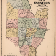
1876 Beers, Shows allotments, towns, local place names, post offices, roads, lakes, rivers, railroads.
1883 Colton
1888 Cram
1895 Bien, Shows roads, railroads, settlements, original patents, towns, etc.
1899 TOPO Quad, Shows Saratoga Springs
and towns to its north and west.